Aerial Mapping & Drone Surveys

Unmanned Aerial Vehicles (UAVs) technology has been around for nearly a century, but it certainly wasn’t used in the way we see them used today. As the technology continues to evolve, AUAV continues to stay in step with the ever-changing scope.

At AUAV, we use unique skills and advanced equipment to bring customers a first-class aerial surveying and mapping experience. AUAV strives to provide superior quality aerial drone surveying and mapping services with highly accurate topographic maps and centimetre-level accuracy at any given time.

Equipped with high-end surveying drones and a crew of skilled surveyors, we deliver results faster, enabling our clients to make agile decisions much more quickly.

The resolution of our maps and survey data is usually between 1- 3cm per pixel (1-3cm GSD). We process the data to deliver full 3D terrain models (e.g., DSM, DTM), and the accuracy of the 3D data is generally around 50mm horizontal and 50-80mm vertical.

If you’re interested in Aerial Mapping and Surveying for your next project, contact us today.

What is a Drone Survey?

A drone survey uses drones to capture data with the help of downward-facing sensors, such as LIDAR payloads, RGB, or multispectral cameras. A drone survey with an RGB camera photographs the ground several times from various angles, and each of these images is tagged with coordinates.

A photogrammetry software uses this data to create geo-referenced orthomosaics, 3D models, or elevation models of the project area. Using these maps, information such as volumetric measurements, areas, slope and high-accurate distances can be extracted.

Unlike satellite imagery or manned aircraft, drones have the ability to fly at a much lower altitude, capturing high-resolution and highly accurate data at a much lower cost.

What is Drone Mapping?

Drone mapping is an innovative technique that leverages the power of survey drones to collect aerial images and generate detailed maps and models. This advanced approach to surveying and mapping has revolutionized how data is collected and analyzed in various industries.

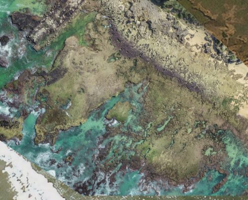
The core of drone mapping lies in its ability to collect aerial images of land surfaces and structures. Equipped with high-resolution cameras, drones capture a series of overlapping images from different angles, covering extensive areas with ease and precision.

Drone Survey Mapping goes beyond mere photography. The images captured by survey drones are processed using specialized software to create comprehensive maps and 3D models. These maps are used for a variety of purposes, including land surveying, construction planning, environmental monitoring, and more.

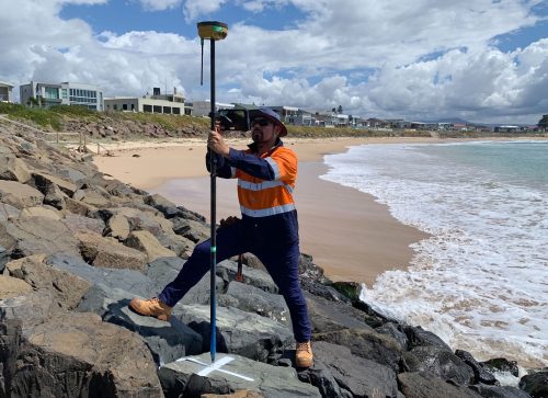
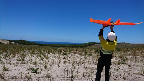
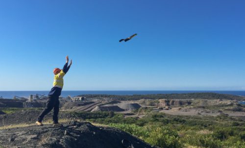
Survey drones are specifically designed for mapping purposes. They are equipped with advanced sensors and GPS technology, enabling them to navigate and cover targeted areas effectively. Their ability to reach difficult or inaccessible terrains makes them an invaluable tool for comprehensive land surveying.

Drone mapping is a technologically advanced method that transforms how aerial images are collected and utilized for accurate measurements and detailed survey mapping. At AUAV, our expertise in drone mapping provides clients with precise, efficient, and comprehensive data, essential for informed decision-making and effective project management.

Why Use Drone Surveying and Aerial Mapping?

Some benefits of using drone surveying and aerial mapping include:

Provide Accurate And Reliable Data A single drone flight can produce thousands of measurements. These can easily be represented in different formats such as point cloud, DTM, contour lines, DSM, orthomosaic, etc. Each pixel of the aerial map or point of the 3D model contains 3D geo-data.
Provide Accurate And Exhaustive Data Quickly An aerial surveying drone captures huge amounts of survey imagery and data of complex and large projects in a short period of time. Aerial surveys are great for reporting quantities and conformance.
Ability To Map Inaccessible Areas Aerial mapping drones are limitless. They can fly almost anywhere – unreachable areas, unsafe steep slopes, or harsh terrain unsuitable for traditional measuring methods.
Safely Track The Progress Of Your Project Drones give you the ability to monitor the progress of your project from a distance. This is a big step towards a more efficient and safer monitoring process.

Drone Mapping and Surveying Service Applications

Drone inspection at sunset.
Some applications where drone mapping and surveying are used include:
  • Geo-referenced orthophotography.
  • Environmental and coastal monitoring.
  • Visual inspection.
  • Topographical surveys for infrastructure development.
  • Land management and development.
  • Volumetric surveys for mines, quarries, and landfills.
  • Coastal erosion monitoring.
  • Visualisation.
  • Land and vegetation classification (NDVI).
  • Precise measurements.
  • Urban planning.
  • Data inputs to flood modelling.
  • Subsidence and landslip analysis.

Why Use AUAV for Drone Survey and Aerial Mapping?

Drone surveying coastal region.
  1. Competitive pricing.
  2. Save time on collecting data.
  3. Safely access dangerous or difficult-to-reach areas.
  4. No delays from interfering with work on the ground (no downtime).
  5. Reduce post-processing time.
  6. Access survey results immediately on InSite – our online data platform.

Frequently Asked Questions

The best drones for surveying include PPK or RTK-enabled drones. Some of them are:

  • Mavic 3E RTK
  • Matrice 300/350 RTK

Our map and drone survey data resolution is usually between 1-3cm per pixel (1-3cm GSD). This data is processed to deliver full 3D terrain models (e.g., DSM, DTM). The accuracy of the 3D data is generally around 50mm horizontal and 50-80mm vertical.

Our standard deliverables include:

  • High-resolution imagery.
  • Surface/terrain models with contours.

Other deliverables include 3D reality modelling for digitising as-built assets.

Get in touch with us today

This field is for validation purposes and should be left unchanged.