
AUAV is working with a number of major ports to facilitate asset inspection and monitoring.
Having completed many projects in ports it has become clear that there are many opportunities to enhance port operations and asset management.

AUAV is working with a number of major ports to facilitate asset inspection and monitoring.
Having completed many projects in ports it has become clear that there are many opportunities to enhance port operations and asset management.
AUAV offers support to your inhouse drone operations, one-off data capture and drone data hosting in our inSite software.
For more information on a specific question or requirement please contact us at contact@auav.com.au.
Our UAVs contain the latest in data-capturing technologies, providing you with high-resolution images of marine and coastal ecosystems. This level of detail allows researchers and managers to monitor sensitive environments, track changes, and detect early signs of environmental stress. This data is able to be processed further before being compared with other large datasets thanks to the high level of accuracy that drones provide.
UAVs can rapidly map marine habitats like coral reefs, seagrass beds, and mangroves. This is invaluable for conservation purposes, helping authorities prioritize areas for protection or restoration.

Coastal areas worldwide are under threat from rising sea levels and erosion. UAVs offer a cost-effective and efficient means to monitor erosion patterns, helping in the development of mitigation strategies.
Drones are proven to provide a simple and cost-effective way of monitoring the stability of a coastline, river or erosion protection structures. With experienced waterway scientists on staff we understand the requirements of the data capture for analysis.
The aerial data captured by the drone is processed into a range of formats depending on the end-use of the data; from orthomosaic imagery in visible and near infra-red for vegetation and change assessments, through to full survey accurate 3D elevation models which are quick and easy to use for inspections and monitoring.

Water utilities manage a vast array of assets to provide their potable water and wastewater services. Drone-based survey and inspection services offer huge time and cost efficiencies, as well as quantifiable safety benefits by removing the need for personnel to gain access to locations.
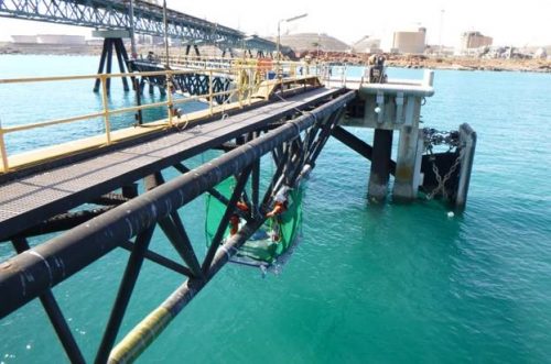
Focusing on the outputs, AUAV has experience with data capture using drones, submersibles and remote bathymetric survey boats. For marine infrastructure and utilities, drones offer a safer, quicker, and more cost-effective inspection method, identifying potential issues before they escalate.
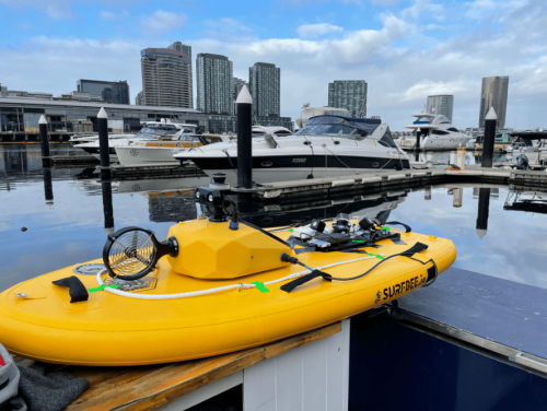
The Surfbee is a state-of-the-art, unmanned surface vehicle (USV) designed specifically for conducting comprehensive marine inspections with efficiency and precision. It serves as an exceptional tool for various maritime sectors, including offshore industries, port authorities, environmental monitoring groups, and research institutions.
The Surfbee is a pivotal asset to AUAV’s range of marine inspections, and compliments our existing suite of commercial drones.


