Our senior staff have decades of experience in consulting environmental engineering companies. We understand that the potential application of drones for mapping and monitoring within the environmental sector is almost endless. The high-resolution aerial imagery can be used to identify existing features either through visual observation or automated classification techniques. We offer a cost-effective tool for planning and monitoring the progress of environmental works programs.
Environmental Sector
Australia’s unique climate and geography demand drones that are robust, versatile, and capable of covering large areas. Compliance with the Civil Aviation Safety Authority’s regulations ensures that drone operations in agriculture are safe and legal.
Our staff are located throughout Australia and frequently travel to remote areas and overseas. With a diverse range of drones and sensors we have the capability in-house to custom integrate sensors and complete the most challenging environmental projects.
Please email us at contact@auav.com.au for more information on specific projects.
Data for Environmental Projects

We have considerable demonstrated experience in:
- Monitoring water birds, pest species and vegetation change.
- Locating and monitoring koala populations.
- Air quality monitoring.
- Mapping and identifying weeds with automated algorithms.
- Monitoring pest mammals with thermal cameras.
- Water flow/discharge volume analysis.
- Assessing pre and post environmental water delivery.
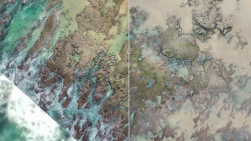
- Monitoring coastal and fluvial erosion and stability.
- Progress reporting to funding agencies.
- Carbon farming reporting.
- Constructed wetland audits.
Landfill and Waste Management
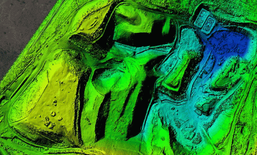
Landfill sites are dynamic and solid waste organisations increasingly require frequent and detailed survey information to manage this ever-changing environment. At AUAV we have flown over 300 landfill surveys across Australia and even one in Antarctica.
Our cost-effective method allows for more frequent surveys to provide the data you need to tightly manage your site. Our approach provides high-resolution and accurate survey outputs. We offer a higher spatial resolution than traditional ground or aerial survey and eliminate the need to access active areas.
Typical turnaround time from a survey data capture to delivery is 48-72 hours. Data can be supplied in either local grid or MGA and is typically compressed and thinned to mitigate problems associated with drone data volume. All data goes through our comprehensive ISO certified quality assurance process prior to delivery.
We currently complete surveys for local government across Australia, Suez, Cleanaway, Hi Quality and other smaller private landfill waste companies.
Our Services Include:
- Topographical surveys.
- Airspace calculations.
- Stockpile volume analysis.
- EPA reporting.
- Drone based landfill gas monitoring.
- Thermal mapping to locate and monitor underground fires.
- Unauthorised filling or dumping of waste monitoring.
Forestry

AUAV has been working with the forestry sector since 2013. We have developed tools to help effectively manage plantations and monitor regeneration.
AUAV has developed a successful drone-based algorithm method for tree counts, regeneration species analysis, tree height, diameter and volume derivation, plantation health and post-fire analysis. We apply a dedicated fixed-wing drone equipped with specific cameras, applying optimised camera settings and lenses.
Our approach provides a complete, repeatable, cost and time-efficient process for analysis of compartments or an entire plantation.
We have Demonstrated Experience in:
- Bluegum plantation survival counts.
- Plantation height and health analysis.
- Monitoring of timber residues post-harvest.
- Disease detection and damage analysis.
- Insurance claim mapping.
- 9-month-old pine tree survival.
- Location of pine wildlings in native forest.
Applications in the Environmental Sector
Vegetation Management
Our drones have revolutionised the field of Vegetation Management. Through advanced aerial imaging and remote sensing technologies, drones can collect extensive data over large areas quickly and efficiently.
This technology allows for the mapping and monitoring of vegetation across vast landscapes, identifying potential problem areas and changes in vegetation health over time. This high-resolution data is invaluable for efficient planning and prioritisation of vegetation maintenance and restoration efforts.
By using AUAV’s commercial drone services, businesses can greatly reduce the resources and time spent on traditional on-the-ground surveys. With our technology, it’s possible to manage vegetation in a more cost-effective, precise, and sustainable way.
Whether it’s monitoring vegetation regrowth after a bushfire, identifying invasive species, or mapping tree canopies for urban planning, our drone services provide detailed insights that support sound Vegetation Management practices. With AUAV, expect better outcomes for your environmental initiatives, all while minimising the impact on natural ecosystems.
Environmental Monitoring and Health Assessment
Regular monitoring is crucial for environmental areas, and drones make it possible to obtain real-time information about crop health, soil conditions, and even plant counting, which is essential for inventory and planning.
Carbon Storage with LiDAR and More
LiDAR technology, as harnessed by AUAV, is making a significant contribution to the growing field of carbon storage, a vital component of global strategies to combat climate change.
By using light detection and ranging (LiDAR) technology, we’re supporting efforts to better understand and manage carbon sequestration processes, enhancing our ability to sustain and protect our planet.
Clients: Environmental
“Utilising new technologies can seem daunting and complex, however Australian UAV made the transition from idea to final product easy with their professional, organised and flexible approach”
– Angela Gladman, North Central Catchment Management Authority


