AUAV has been working with major mining and quarry companies for many years. We have established long term service contracts with clients and pride ourselves on our reliable and accurate data. With third party audited ISO certification in Quality, Safety and Environmental systems you can engage us with confidence.
Mining & Minerals Sector
If you like to discuss a particular project or how drones might assist operations generally please send us a message at contact@auav.com.au.
BARS Accredited and Standard 11 Inducted
![]()
Applications for Mining Companies
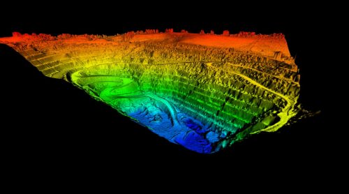
Through AUAV’s proprietary data management software; inSite™, we are able to provide companies all across the mining industry with digital twins of their assets.
The data this software gathers can be used for getting quality asset inspections with superior detail. This in turn makes making faster data collection, easier problem identification, and reduced risks during significant mining operations a lot easier to do.
Using Drone Technology to Help Mine Sites
Our team can provide one of the most comprehensive marine drone and unmanned aerial vehicle (UAV) services in the world – complete with full 3D laser scanning, photogrammetry & digital twinning.
Projects across the mining industry are constantly aiming to improve efficiency and reduce risk across their mining sites. Our range of drone survey, inspection, and site capture technology and services can provide this, being able to ensure all core and other significant mining operations continue to run smoothly.
Improving and Optimising Safety on Every Mining Site
The mining sector has long been known to be a somewhat hazardous and dangerous profession. Because of this, many subterranean and surface mining operations are always looking to improve the safety levels of each mine site they operate.
AUAV’s drone technology is able to perform more rapid data collection than other methods, allowing for quicker analysis of possible safety issues in relation to mining equipment and the surrounding environment. Drones in mining are becoming even more efficient, meaning these drone surveys will only become more beneficial.
Data for Mining & Quarrying

The adaptability, precision, and efficiency of UAVs have made them an indispensable tool for modern mining operations.
By providing an aerial view of the entire mining site, drones can create detailed topographical maps, get real-time insights into extracted materials, monitor environmental quarrying impacts, and more.
Mining and Quarrying are ideal cases for drone data capture, assisting with services such as:
- Stockpile measurement and reporting on mining exploration projects.
- Full site survey and digital surface models in order to observe mine site components.
- Environmental monitoring and management, including vegetation auditing.
- Inspection of ancillary infrastructure such as rail lines or processing plants.
- 3D site capture to assist with safety and compliance issues, e.g. site inductions, traffic management, road gradients, safety signage, buffer zones, incident reporting.
- Bathymetry survey of dams and ponds.
- Asset inspection for conveyors, bins, chutes and communication towers.
- We can also support you to get your own mining drones program underway.
Clients: Mining & Quarrying


